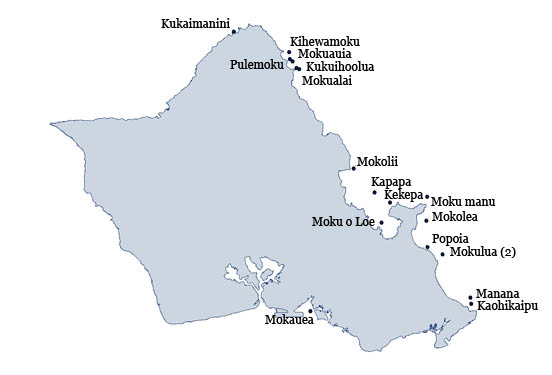
HOME > O'AHU ISLETS

O'ahu islet map

For more information click on an islet name on the map or select from the list below. Islets that are washed over by waves and lack any flora or fauna are not detailed here.

> Kaohikaipu (Black Rock)

> Kapapa (Mokukapapa)

> Kekepa (Turtle Rock)

> Kihewamoku

> Kuka'imanini

> Kukuiho'olua

> Manana (Rabbit Island)

> Mokauea

> Mokolea

> Mokoli'i (Chinaman's Hat)

> Moku manu

> Moku o Lo'e (Coconut Island)

> Mokualai

> Moku'au'ia (Goat Island)

> Mokulua

> Popo'ia (Flat Island)

> Pulemoku

Mokauea
Mokauea
Photo: H. Eijzenga

Mokauea is located in Keehi Lagoon off Sand Island and is home to four families. The island ranges in size from 9 to 14 acres depending on the tide.
The islet is State owned but is leased to residents. All native flora and fauna on the islet is protected under State and/or federal law.

Field Accounts: 8 Sep 2007; 10 Nov 2007
Literature Citations:

MacCaughey, V. 1918. The strand flora of the Hawaiian Archipelago-I. geographical relations, origin, and composition. Bulletin of the Torrey Botanical Club 45(7): 18.

Nichols, K. 2007. Rebirth of Mokauea. Honolulu Star-bulletin 2007 (July 5, 2007)

KaohikaipuKapapaKekepaKihewamokuKuka'imaniniKukuiho'oluaMananaMokaueaMokoleaMokoli'iMoku manuMoku o Lo'eMokualaiMoku'au'iaMokuluaPopo'iaPulemoku