 |
|
Kapukaloa (White Rock)
|
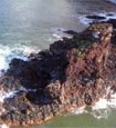
Aerial photo
Photo: Starr
|
A small islet less than 1 acre in size located just north of the Nanahoa islets.
The islet is State owned and all native flora and fauna on the islet is protected under State and/or federal law.
|
|
| Literature Citations: | Starr, F., Starr, K. & Wood, K. 2006. Lana'i offshore islets botanical survey. Department of Land and Natural Resources, Divsion of Forestry and Wildlife, Honolulu. 57 p. |
|
| |

|