 |
|
Pa'uonu'akea
|

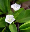
pa'uohi'iaka flowers
Photo: H. Eijzenga
|
0.5 acre islet located offshore Kalaupapa peninsula.
The islet is State owned and all native flora and fauna on the islet is protected under State and/or federal law.
|
|
| Species checklists: | | PLANT | | Family: Cyperaceae | | | Fimbristylis cymosa subsp. umbellato-capitata (Coastal Sedge) Fed:none State:none | Indigenous | | 28-Aug-84 | Partial survey | Rare | Hobdy 1984 | | Family: Goodeniaceae | | | Scaevola sericea Naupaka kahakai Fed:none State:none | Indigenous | | 28-Aug-84 | Partial survey | Occasional | Hobdy 1984 | | Family: Poaceae | | | Eragrostis variabilis Emoloa, kawelu Fed:none State:none | Endemic | | 28-Aug-84 | Partial survey | Rare | Hobdy 1984 | | Family: Rosaceae | | | Osteomeles anthyllidifolia Ulei (Hawai'i hawthorn) Fed:none State:none | Indigenous | | 28-Aug-84 | Partial survey | Rare | Hobdy 1984 |
| | Literature Citations: | Anonymous. Maui county's offshore islets general information. Maui County. 2 p. Hawaii, S.o. 1969. Geographic names approved, second quarter 1969, p. 8. In: Development, D.o.P.E. (ed.), State of Hawaii8. Hobdy, R. 1984. The vegetation of Pauonuakea Islet. Department of Land and Natural Resources, Division of Forestry and Wildlife, Maui County. 1 p. | Additional information |
|
| |

|

